Raster maps
By default, TwoNav opens the best map based on your current position automatically. If you prefer to manage your maps manually, disable the ‘Auto-open maps’ function from ‘Main menu > Settings > Full settings > Map page > Automaps’.
|
|
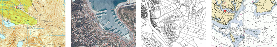
Raster maps |
Maps digitally calibrated based on bitmap images (if map is scaled, there will be loss of clarity, the quality of the map will degrade).
|
|
|
Topographic: Maps containing information related to the relief of the terrain (elevation contour lines, pathways, national parks…).
Orthophoto: Maps containing aerial photographs with information related to all elements included in the landscape (fields, lakes, roads, buildings, national parks…).
Cadastre: Maps containing information related to limits of all terrain parcels (fields, roads, buildings…).
Marine chart: Maps containing nautical information related to the sea (depth data, ports, marine services, tides, currents, marine wrecks…). |
|
|
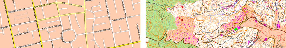
Vectorial maps |
Maps digitally calibrated based on vectors (if map is scaled, there will be no loss of clarity, the quality of the map will not degrade).
|
|
|
Urban: Maps containing information related to roads and streets (names of the streets, street directions, points of interest…).
Topographic: Maps containing information related to the relief of the terrain (elevation contour lines, pathways, national parks…). |
|
|
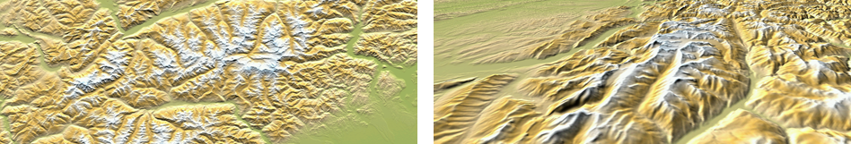
3D relief maps |
Maps digitally calibrated based on elevation reliefs containing information related to the altitude of the ground. With a relief map loaded you may display your maps in 3D+ mode.
|
|
|
|
On-line maps |
Remote maps only accessible if internet connection is provided.
|
|
Locked maps |
Maps not activated. In order to start working with them, enter a license code.
NOTE: CompeGPS offers you a wide range of maps from all around the world to complement your cartography, just visit http://www.CompeGPS.com
See your list of available maps from ‘Main menu > Files > Maps’ (all maps available at ‘TwoNavData/Maps’ folder for your present position). TwoNav can open the following map formats depending on the device:
|
|
|
|
|
|
|
|
|
|
|
|
|
|
|
|
|
|
|
|
|
|
|
|
In addition to maps, you can also work with different position references for guidance: waypoints (separate points), routes (a sequence of waypoints), tracks (itinerary footprint)... You can get these references by creating them yourself or from other sources (friends, webs, meeting planners...).
|
|