Before getting out with your GPS it is very important to properly calibrate the device so that it offers accurate data. The default setting usually offers the best results for most users. The barometric altimeter is self-calibrating, but the electronic compass must be manually calibrated whenever it detects inaccuracies in its operation:
•Take altitude from: Your device offers you different ways to determine the altitude value you are taking during your navigations:
•GPS: Altitude data from the GPS will be used.
•3D relief (altitude map): Current altitude of the 3D relief map (3D relief map must be loaded).
•Barometric (manual): Values from the barometric altimeter will be used.
•Barometric (autocalibrated by GPS): Barometric altitude will be used, but the barometer will be automatically calibrated using the altitude data from the GPS by means of an algorithm that optimizes the final result.
•Barometric (autocalibrated by CDEM): Barometric altitude will be used, but the barometer will be automatically calibrated using the altitude data of the 3D relief map (3D relief map must be loaded).
•Calibrate barometric altimeter: It is very important to calibrate the barometer in order to achieve reliable data, your device provides you several ways to calibrate it:
•Enter altitude manually: If you know the current altitude, enter it.
•Take altitude from current GPS: Takes the current altitude from the GPS by means of an algorithm that optimizes the final result.
•Take altitude from current 3D relief: Takes the current altitude from the 3D relief map (3D relief map must be loaded).
NOTE: This option might minimize little errors of altitude data from the GPS. It also overcomes limitations of the barometric altimeter regarding atmospheric pressure and temperature, alien to altitude changes.
•Take bearing from: Your device offers you different ways to determine the bearing you are taking during your navigations:
•GPS: The latest positions received are used to calculate the bearing of your current movements. As soon as you stop, this reference will not be reliable because there will be no reliable movements to calculate the bearing.
•Compass: Data recorded from the compass will be used in order to determine the orientation of the device.
•Automatic (recommended): Data recorded from the compass will be used (if driving slowly) while GPS position will be used (if driving fast).
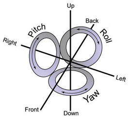
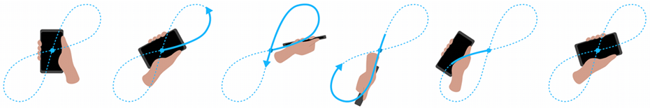
•Calibrate compass: The calibration of the electronic compass is essential in order to display right directions during your navigations. After pressing the button, follow the steps shown on the screen. Rotate the device for a few seconds to do the calibration. It is important to move the device about all 3 axes of rotation. This effect can be achieved in 2 ways:
•Figure-8 motion: Not a flat figure-8. The device must be rotated while moving it to capture readings in all 3 axes.
•Sequential rotation about the 3 axes:
|
| |
|
|
X-axis: Longitudinal (yaw)
Y-axis: Vertical (roll)
Z-axis: Transversal (pitch) |
IMPORTANT: The electronic compass is an instrument very sensitive to weather conditions and magnetic fields. Calibration must be carried out in the open air and far from sources of alterations of the magnetic fields, such as cars, buildings or electric lines.