Rasters
|
|
Rasters |
Maps digitally calibrated based on bitmap images (if map is scaled, there will be loss of clarity, the quality of the map will degrade).
|
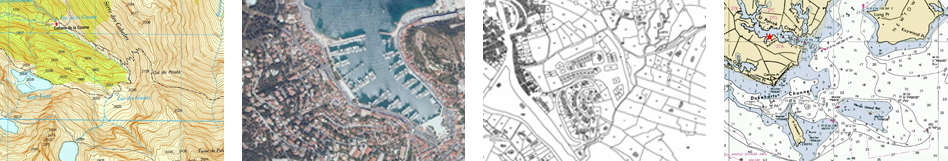
Topographic: Maps containing information related to the relief of the terrain (elevation contour lines, pathways, national parks…).
Orthophoto: Maps containing aerial photographs with information related to all elements included in the landscape (fields, lakes, roads, buildings, national parks…).
Cadastre: Maps containing information related to limits of all terrain parcels (fields, roads, buildings…).
Marine chart: Maps containing nautical information related to the sea (depth data, ports, marine services, tides, currents, marine wrecks…). |
|
|
Vectorials |
Maps digitally calibrated based on vectors (if map is scaled, there will be no loss of clarity, the quality of the map will not degrade).
|
|
|
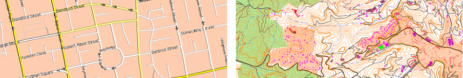
Urban: Maps containing information related to roads and streets (names of the streets, street directions, points of interest…).
Topographic: Maps containing information related to the relief of the terrain (elevation contour lines, pathways, national parks…). |
|
|
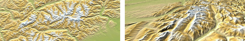
3D reliefs |
Maps digitally calibrated based on elevation reliefs containing information related to the altitude of the ground. With a relief map loaded you may display your maps in 3D mode.
|
|
|
|
Locked maps |
Maps not activated. In order to start working with them, enter a license code.
Land can open the following map formats depending on the device:
|
|
|
|
|
|
|
|
|
|
|
|
|
|
|
|
|
|
|
|
|
|
|
|
|
|
|
|
|
|
|
|
|
|
|
|
|
|
|
|
Land can open the following 3D relief map formats depending on the device:
|
|
|
|
|
|
|
|
IMPORTANT: Some maps are protected against illegitimate copies. In such situations you must enter a registration code to use the map.
Map properties
A map is a flat graphical representation of a portion of the earth’s surface. A map presents several properties:
•Scale: Relation between the dimensions of the elements drawn on the map and their real value measured on the earth’s surface (example: 1:25.000).
•Resolution: Relation between the distance of the ground in meters and a pixel (meters/pixel). A fewer number will represent a more detailed map.
•Projection: All maps are approximate representations of the surface of the earth on a flat surface. The creation of any map uses a method that associates each point on the earth’s surface with a point drawn on a map. Different types of cartographic systems are used to make this association. There are several different types of cartographic projection that are classified depending on the areas they cover (example: UTM, Lat./Long., Mercator…).
•Datum: Datums are used to translate the positions of elements (waypoints/routes) to the exact position on the earth. Datum systems are needed because the earth is an imperfect ellipsoid (example: WGS84, NAD83, NAD27, OSGB36, ED50, PSAD56…).
•Coordinates: Table of latitude and longitude readings based on the meridians and parallels that indicate the relative situation of a point on the earth’s surface.
•Calibrating points: Number of points used to calibrate the map.
•Primary: In case of conflict between maps, if this field is marked, other maps will be adapted to this one.
•Size of the bitmap: Size of the image that the map comes from.
•Extension: Width and height of the area covered by the map.
•Rows/Columns: Number of rows/columns the landscape is made up of (altitude/width)
•3D picture using vectors: Indicates if the vectors will be used to represent the 3D mode.
•Number of vectors: Number of vectors composing the map.
•Number of points: Total amount of points composing the map.
•Number of entities: Stores the number of polygons.
•Far/Near zoom: Maximum and minimum zoom values between which the map is visible on the screen. These values allow to enlarge or decrease the size of the map up to the limitation of these settings.
IMPORTANT: By default, Land opens the best map based on your current position automatically. If you prefer to manage your maps manually, disable the ‘Auto-open maps’ function from ‘Buttons bar > Options > Maps’.
NOTE: TwoNav offers you a wide range of maps from all around the world to complement your cartography, just visit http://www.TwoNav.com